
Barclay Sound, West Coast, Vancouver Island
- CA JMABC A.1985.001-1-36-LF.01174
- Item
- [1925]
Photograph depicts Barclay Sound.
Rocky shoreline jutting out into water; more protrusion in middle of image; snow capped mountain peaks in background.
16 results with digital objects Show results with digital objects
Barclay Sound, West Coast, Vancouver Island
Photograph depicts Barclay Sound.
Rocky shoreline jutting out into water; more protrusion in middle of image; snow capped mountain peaks in background.
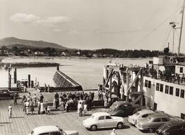
Cars on ferry dock, Sidney, Vancouver Island, B.C.
Photograph depicts cars parked at the ferry dock in Sidney on Vancouver Island.
Six cars parked in foreground; crowd of people milling around recessed gangplank leading into ferry; people on ferry deck; ocean, houses, and mountains in background.

Butchart Gardens, Victoria, B.C.
Photograph depicts people at Burchart Gardens.
Two groups of people standing on pathway through landscaped area; willow trees and lily pond in foreground of image; more trees in background.

Butchart Gardens, Victoria, B.C.
Photograph depicts people at Burchart Gardens.
Two women standing to the right of a variety of shrubs and flowers planted in flower bed; pond to right of women; trees and hillside in background.

Old logging camp, Nimpkish Lake
Photograph depicts an old logging camp at Nimpkish Lake.
Railways tracks and foliage in foreground of image; old logs litter shoreline; houses built on dock in lake; mountains and forest in background.
Barclay Sound, near Bamfield Creek, Vancouver Island
Photograph depicts Barclay Sound, near Bamfield Creek, Vancouver Island, British Columbia.
Landscape shows a sand beach with waves washing in over shell-encrusted rocks and sharp, tall rocks topped by craggy trees extending into the ocean.
West Coast Vanc. Island, near Barclay Sound
Photograph depicts a beach near Barclay Sound, Vancouver Island, British Columbia.
Landscape shows a beach with waves; steep, rocky land appears in the distance.
Photograph depicts aerial image of Nanoose Bay.
Placid water along shoreline in foreground of image, labelled "close up of receiving WHARF and BARGE SLIP POWER HOUSE, WAREHOUSES and part of VILLAGE"; wharf and warehouses along shoreline; forested area in background.
Aerial view of Nanoose Bay, Notch Hill, the lake and Gulf of Georgia
Photograph depicts Notch Hill and the Gulf of Georgia.
Aerial view of ocean coastline, labelled "PHOTO BY PACIFIC AIRWAYS LTD.", "NOTCH HILL, The LAKE, and GULF OF GEORGIA"; bare hillside and forested plateau; bay in background.
Photograph depicts the approach to Esquimalt and the Nanaimo Railway.
Aerial view of road and railway cut through farm land and forest; small lakes sporadically coloured blue.